Slope map for Lapland and Norway
Levi slope map
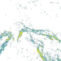
Levi is a well-known fell and ski area in Lapland, where ski slopes, open high ground, forests, and valley terrain sit close together. The Slope Hylly map helps you look at Levi terrain steepness before planning a route, climb, descent, or day outside.
Levi terrain steepness on the map
The slope map shows where Levi terrain changes from gentler forest sections into steeper slopes, and where the fell forms longer continuous tilted areas. It complements ordinary map reading by making steepness quicker to understand.
Using the Levi slope map for route planning
Use the map when comparing slopes around Levi, looking for gentler lines, or checking how fell terrain changes into forested and flatter sections. Always confirm final route choices with current local information.
Levi and avalanche terrain
Slope steepness matters in winter, but avalanche risk needs much more than a map. Check official avalanche bulletins, weather forecasts, snow conditions, and local observations. Use this map as one planning aid only.
The map does not replace local knowledge, official warnings, weather forecasts, avalanche bulletins, navigation, or professional judgment.
How to use the Levi slope map
Open the map, zoom to the area you are interested in, and compare several possible lines side by side. Look for places where the terrain becomes steeper quickly and where gentler alternatives might run.
Data sources
The map is based on open land survey data from the National Land Survey of Finland and the Norwegian Mapping Authority. It shows general terrain shape, not current snow, weather, or route conditions.
For Finnish areas, you can also use Hylly map and weather pages as part of your planning:
Open Levi on the map
Explore the slopes and terrain steepness around Levi with the Slope Hylly map. Use it for early comparison of areas and route options before more detailed planning.