Slope map for Lapland and Norway
Narvik slope map
Narvik sits in northern Norway among mountains and fjords. The mountains drop toward the coast, elevation changes can happen quickly, and winter route planning benefits from careful comparison of terrain steepness.
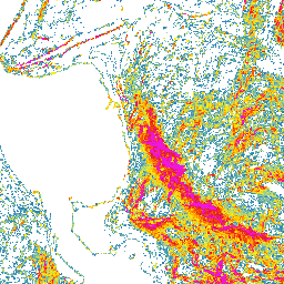
Narvik terrain steepness on the map
The Narvik slope map helps show how mountains, fjords, valleys, and slopes around the town connect. On the map you can see where slopes are gentler, where they steepen, and where terrain forms longer tilted sections.
Using the Narvik slope map for route planning
Use the map first to build an overview of the area. Look at the direction of mountains, fjords, and valleys, zoom to a slope or route that interests you, and compare steepness before final choices.
Narvik and avalanche terrain
Slope steepness matters in winter, but avalanche risk needs much more than a map. Check official avalanche bulletins, weather forecasts, snow conditions, and local observations. Use this map as one planning aid only.
The map does not replace local knowledge, official warnings, weather forecasts, avalanche bulletins, navigation, or professional judgment.
How to use the Narvik slope map
Open the map, zoom to the area you are interested in, and compare several possible lines side by side. Look for places where the terrain becomes steeper quickly and where gentler alternatives might run.
Data sources
The map is based on open land survey data from the National Land Survey of Finland and the Norwegian Mapping Authority. It shows general terrain shape, not current snow, weather, or route conditions.
Open Narvik on the map
Explore the slopes and terrain steepness around Narvik with the Slope Hylly map. Use it for early comparison of areas and route options before more detailed planning.