Slope map for Lapland and Norway
Lyngen slope map
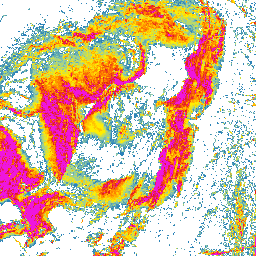
Lyngen is one of northern Norway’s best-known mountain areas. Steep slopes, narrow valleys, fjords, and quickly changing terrain make slope steepness especially important to understand before comparing route options.
Lyngen terrain steepness on the map
In the Lyngen mountains, elevation can change a lot over a short distance. The slope map shows where slopes move from gentler sections into steeper terrain zones, and how mountains, valleys, and fjord-side slopes relate to each other.
Using the Lyngen slope map for route planning
Use the map as a first planning step: look at the broad terrain shape, zoom to the area you care about, and compare steepness with the surrounding terrain. This helps show where a route might follow gentler ground and where it meets steeper slopes.
Lyngen and avalanche terrain
Slope steepness matters in winter, but avalanche risk needs much more than a map. Check official avalanche bulletins, weather forecasts, snow conditions, and local observations. Use this map as one planning aid only.
The map does not replace local knowledge, official warnings, weather forecasts, avalanche bulletins, navigation, or professional judgment.
How to use the Lyngen slope map
Open the map, zoom to the area you are interested in, and compare several possible lines side by side. Look for places where the terrain becomes steeper quickly and where gentler alternatives might run.
Data sources
The map is based on open land survey data from the National Land Survey of Finland and the Norwegian Mapping Authority. It shows general terrain shape, not current snow, weather, or route conditions.
Open Lyngen on the map
Explore the slopes and terrain steepness around Lyngen with the Slope Hylly map. Use it for early comparison of areas and route options before more detailed planning.