Abisko slope angle map
Abisko is a village on Lake Torneträsk in Kiruna municipality, Sweden, next to Abisko National Park, the Kungsleden trailhead and the mountain Nuolja (Njullá, 1164 m). On the slope angle map the village and valley are almost entirely uncoloured, while about a third of Nuolja's east side and a quarter of its north side are 30° or steeper.
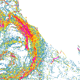
How steep is the terrain around Abisko?
Within 1.5 km of the Nuolja summit, about a sixth of the terrain is 30° or steeper on the map. The east side has the most colour, with about a third at 30° or steeper, and the north side towards Torneträsk about a quarter; the south and west sides are mostly uncoloured. Slåttatjåkka (1186 m) is about three quarters uncoloured, with most colour on its south side. Around Björkliden's ski area about a tenth is 30° or steeper, and 45° and steeper shows only in isolated spots. Almost all of Abisko village and about nine tenths of the Abiskojåkka canyon are uncoloured. Further south-east, more than a third of the terrain around Nissuntjårro at Lapporten is 30° or steeper.
Planning a trip to Abisko: zones, access rules and slope angle
The Swedish Tourist Association (STF) runs a chairlift from Abisko Turiststation to Aurora Sky Station on Nuolja; Nuolja Offpist below it is ungroomed, not avalanche-controlled and unpatrolled. Björkliden has lift-accessed off-piste, guided tours from about February to early May and trails to Låktatjåkko mountain station (1228 m). STF lists many ski touring peaks between Abisko and Narvik. Nuolja is partly inside Abisko National Park: camping only at designated sites, dogs on a lead and from May to December only on roads and marked trails, snowmobiles only on marked routes. Search for Abisko or Njullá, Nuolja's name on the map.
Where to check the avalanche forecast for Abisko
The official avalanche forecast comes from Lavinprognoser.se, run by Naturvårdsverket (the Swedish Environmental Protection Agency); its Abisko/Riksgränsfjällen area covers Nuolja, Björkliden, Lapporten and Riksgränsen. It is published in winter only; out of season the page shows 'Not assessed'. The service warns that avalanches can reach flatter terrain below steep slopes. SVT reported that in March 2023 an avalanche 400–500 m wide released below Nuolja.
This map is not an avalanche forecast or a safety assessment: base your decisions on the official forecast, the weather and what you see on site.
How to read the slope classes
The colours start at 20°; the six classes are listed below. Terrain with no colour is below 20° or a gap in the source data. The map gives no point values: compare each colour with the legend, and zoom in, because when zoomed out each pixel shows the steepest value in the area it covers.
- 20–24° blue
- 25–29° light green
- 30–34° yellow
- 35–39° orange
- 40–44° red
- ≥45° magenta
Data and grid size
The slope classes are computed from the official elevation model named below, on a 2 m grid. They show terrain shape, not snow, weather or trail conditions.
- Published resolution
- 2 m
- Coordinate system
- EPSG:3006
- Coverage checked
- 2026-10-03
Open Abisko on the slope angle map