Pyhä-Luosto slope angle map
Pyhä-Luosto National Park in Finnish Lapland has two groups of fells, open treeless hills: the Pyhätunturi chain, up to 540 m at Noitatunturi, and the Luosto fells about 20 km north-west. On the slope angle map the densest colour is in the Isokuru gorge between Kultakero and Ukonhattu, where more than half the terrain is 30° or steeper.
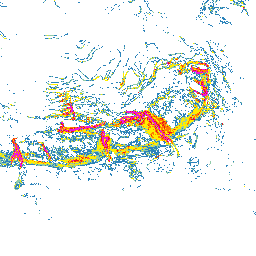
How steep is the terrain around Pyhä-Luosto?
On the map, a third to two fifths of the terrain around the three main Pyhätunturi tops is 20° or steeper. Around Noitatunturi (540 m) about a tenth is 30° or steeper, mostly on the east side; Ukonhattu carries colour on its east and west slopes, above Isokuru and Pikkukuru. In Isokuru more than four fifths is coloured and more than half is 30° or steeper; all six classes appear, with 45° and steeper mostly around Pyhänkasteenlampi. On Kultakero, groomed pistes and natural fell slopes are coloured alike. Around Ukko-Luosto (514 m) at Luosto under a quarter is coloured, and 35–39° appears only in short sections.
Planning a trip to Pyhä-Luosto: zones, access rules and slope angle
Outside the national park's restriction zones you may walk and ski tour freely. In the Isokuru zone only the marked summer trail may be used, no winter route enters the gorge because of avalanche danger, and freeriding is prohibited all year; the Peurakero zone is closed from 15 February to 31 May. At the Pyhä ski resort, skinning during opening hours is allowed only on the marked uphill route, and the resort classifies its Huttu freeride area as avalanche terrain. The Ukko-Luosto stairs cross avalanche-prone terrain and are not maintained in winter. On the map, the most colour lies along the Isokuru, Pikkukuru and Aittakuru gorges.
Where to check the avalanche forecast for Pyhä-Luosto
There is avalanche danger in Isokuru in winter, and in March 2026 a skier who entered the restricted zone triggered an avalanche there (Kaleva). Luosto-Pyhä is one of the six regions in the official avalanche forecast of the Finnish Meteorological Institute (FMI), updated daily by 16:00 for three days ahead from about December or January to late April, for unmanaged natural slopes only. For the Pyhä area, Pyhän Lumiturvallisuuskeskus, the local snow safety centre, publishes its own forecast on a five-level scale.
- Finnish Meteorological Institute: avalanche forecast (Luosto-Pyhä region)
- Pyhän Lumiturvallisuuskeskus: local avalanche forecast for the Pyhä area (in Finnish)
- Luontoon.fi (Metsähallitus): rules of Pyhä-Luosto National Park (in Finnish)
This map is not an avalanche forecast or a safety assessment: base your decisions on the official forecast, the weather and what you see on site.
How to read the slope classes
The colours start at 20°; the six classes are listed below. Terrain with no colour is below 20° or a gap in the source data. The map gives no point values: compare each colour with the legend, and zoom in, because when zoomed out each pixel shows the steepest value in the area it covers.
- 20–24° blue
- 25–29° light green
- 30–34° yellow
- 35–39° orange
- 40–44° red
- ≥45° magenta
Data and grid size
The slope classes are computed from the official elevation model named below, on a 2 m grid. They show terrain shape, not snow, weather or trail conditions.
- Published resolution
- 2 m
- Coordinate system
- EPSG:3067
- Coverage checked
- 2026-10-03
Open Pyhä-Luosto on the slope angle map