Ruka slope angle map
Ruka is the fell Rukatunturi and its ski resort in Kuusamo, North Ostrobothnia, Finland; Valtavaara and Konttainen lie to the north-east. On the map, about a fifth of the terrain around the summit is 20° or steeper; the most 30° and steeper terrain is in the Surmanoro valley and at the Juhannuskallio cliff, where 45° and steeper appears.
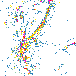
How steep is the terrain around Ruka?
Within about a kilometre of the Rukatunturi summit, roughly a fifth of the terrain is 20° or steeper on the map. Most colour is on the north and south sides, the east side is almost uncoloured, and the two steepest classes appear in short sections. Pistes and natural slopes are coloured alike, so this is not the piste map. Around the Juhannuskallio cliff, about 1 km south of the summit, about a third is coloured, most of it on the west side. On Valtavaara the colour lies north and west of the top; in Surmanoro, a small valley on the summit ridge, nearly half is 20° or steeper and about a fifth 30° or steeper. Konttainen has the most colour on its south and west sides.
Planning a trip to Ruka: zones, access rules and slope angle
Ruka ski resort prohibits ski touring in the resort area and on the pistes, and any use of the pistes outside opening hours. Valtavaara, Konttainen, Pyhävaara and Juhannuskallio belong to the Valtavaara-Pyhävaara Nature Reserve, where you may walk, snowshoe and ski freely; the tip of the Juhannuskallio cliff is closed from 1 April to 15 August. The hardest stage of the Karhunkierros trail, Porontimajoki to Saarua, crosses Konttainen and Valtavaara and is not maintained in winter. Pyhävaara is 3.6 km south of the Rukatunturi summit; Oulanka National Park lies further north-east.
Where to check the avalanche forecast for Ruka
The Finnish Meteorological Institute issues the official avalanche forecast for the Ruka region, one of six fell areas on one page, daily for three days ahead from December or January to late April. It covers unmanaged natural slopes, not groomed pistes. Ruka.fi warns of avalanche danger in parts of Valtavaara-Konttainen and asks anyone off marked routes to find out where the avalanche areas are and carry proper equipment.
- Finnish Meteorological Institute: avalanche forecast
- Finnish Meteorological Institute: background on avalanche warnings
- Luontoon.fi (Metsähallitus): avalanche safety for hikers (in Finnish)
This map is not an avalanche forecast or a safety assessment: base your decisions on the official forecast, the weather and what you see on site.
How to read the slope classes
The colours start at 20°; the six classes are listed below. Terrain with no colour is below 20° or a gap in the source data. The map gives no point values: compare each colour with the legend, and zoom in, because when zoomed out each pixel shows the steepest value in the area it covers.
- 20–24° blue
- 25–29° light green
- 30–34° yellow
- 35–39° orange
- 40–44° red
- ≥45° magenta
Data and grid size
The slope classes are computed from the official elevation model named below, on a 2 m grid. They show terrain shape, not snow, weather or trail conditions.
- Published resolution
- 2 m
- Coordinate system
- EPSG:3067
- Coverage checked
- 2026-10-03
Open Ruka on the slope angle map