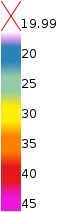
A slope map for route planning
Slope Hylly shows terrain steepness in a simple visual map. It helps you see where slopes ease off, where the terrain gets steeper, and how fells, valleys, and fjord-side mountains fit together.
Use the map as an early planning aid when comparing ski tours, descents, climbs, or summer hiking routes. It does not choose a route for you, but it makes the shape of the terrain easier to understand.
If the term is new, start with the short explanation: what does steepness mean on a map?
A steepness map shows slope angle
The steepness map adds a visual slope-angle view on top of ordinary map reading. It is useful when you want to compare route options, look for gentler terrain, or notice where the ground becomes steeper quickly.
It can help with ski-touring planning, freeride pre-planning, hiking in fell terrain, and general terrain reading before you study the details more closely.
What does steepness mean on a map?
Steepness describes how quickly the ground rises or drops along a slope. On a map, it helps you see at a glance whether terrain is gentle, clearly rising, or already steep.
Steepness alone does not say whether a route is easy or safe. Surface, snow, ice, visibility, wind, experience, and equipment all affect how a route feels in the terrain.
Map coverage: Finland, Lapland, and Norway
Slope Hylly focuses on supported areas in Finland, Lapland, and Norway. The map is most useful in fell and mountain terrain where slope angle changes clearly.
Area pages highlight real supported locations with a static preview image, map link, local description, and clear limitations.
Covered areas
Area pages give you a quick local map link, a short description, and clear reminders about the limits of the map.
Avalanche terrain and slope steepness
Slope steepness is one terrain factor used when thinking about avalanche terrain. A slope map can help you notice where terrain becomes steeper and where gentler alternatives may exist.
The map is not an avalanche forecast or a safety tool. Always check official avalanche bulletins, weather, snow conditions, and local observations before going into the mountains.
Hylly.org maps
Slope Hylly is part of the Hylly.org map ecosystem. If you need other map views, you can move to the map hub from the same collection.
Data sources
The map is based on open land survey data from the National Land Survey of Finland and the Norwegian Mapping Authority. The data helps show the general shape of the terrain, but it does not include current snow, weather, or route conditions.
Use it safely
A slope map is a planning aid, not a safety assessment. It does not replace local knowledge, official warnings, weather forecasts, avalanche bulletins, navigation skills, or professional judgment.
Always check current conditions before going into the mountains and use this map as just one part of careful planning.